
Steep Lot, Limestone Bluff, Lake Below: How Lago Vista, TX Landscape Design Keeps a Hillside Where You Put It | Heroes Lawn Care of Cedar Park
A flat lot forgives almost everything. Water wanders off slowly, soil stays where it was spread, and a planting mistake is just a planting mistake. A steep lot above Lake Travis forgives nothing. Every inch of grade is a decision about where water will run, every exposed bluff is a reminder of what the ground is made of, and every shortcut in the first year becomes a gully by the third. Yards in Lago Vista, TX are built on that kind of terrain, which is why landscape design here is as much engineering and ecology as it is aesthetics.
The best hillside landscapes are not the ones that fight the slope. They are the ones that read it, slow the water, hold the soil, and then plant into the structure that results. Heroes Lawn Care of Cedar Park approaches steep Lake Travis lots in that order: understand the ground and water first, shape the terrain next, protect the view and the property from fire third, and let the planting and the outdoor living areas follow. The sections below walk through that sequence.
Why a Lago Vista, TX Hillside Behaves Differently
The Ground Is Mostly Rock
Much of the land around Lago Vista sits on limestone, with thin soil layered over bedrock and ledges that break through the surface in places. That has consequences. Thin soil holds little water and drains quickly, so plants dry out fast in summer. The rock beneath prevents deep digging, which complicates footings, trenching, and planting holes. And when heavy rain falls, water cannot soak in very far, so a large share of it runs across the surface and down the slope.
Water Wants to Leave
The lake below makes this more than a property-line concern. Whatever leaves a hillside yard eventually reaches Lake Travis, carrying soil, nutrients, and anything else it picks up along the way. That connection is why drainage design on these lots is treated as part of caring for the shoreline, and not only as a way to protect the house.
On a hillside, water is the main force shaping the land. Intense Hill Country storms deliver rain faster than thin soil can absorb it. The runoff collects, gains speed, and carries soil and gravel downhill toward the street, the neighbor, or the lake. Anything that interrupts that flow, such as a berm, a swale, a rock apron, or a dense planting, helps. Anything that concentrates it, such as a downspout dumping onto bare ground, accelerates the damage. A thoughtful design treats water as the starting point.
The View Is Part of the Value
Hillside lots in Lago Vista are prized for what they see. The ground slopes away toward the water, and the horizon opens across the lake. Landscaping on these lots has to work with that view, framing it instead of blocking it. Tall trees in the wrong place can erase the lake from the living room window in a decade, and a hillside planted without a view plan can lose the very thing that makes the property special.
Start With the Picture: Master Planning and Rendering
3D Photo-Realistic Landscape Master Plan Rendering
Hillside design benefits more from visualization than almost any other kind. A flat plan view hides what a slope actually looks like. A 3D photo-realistic landscape master plan rendering shows the terrain, the terraces, the plantings, the structures, and the view from the places where people will stand and sit. It can be viewed from the deck, from the street, from the lake, and from the walkway halfway down the slope.
Rendering also shows time. A plan can illustrate how a small tree will grow into a large one, and what it will do to the sightline in ten years. Walls, steps, and planting beds are shown in context, which makes it easier to judge proportions and relationships before any ground is disturbed. Decisions that would otherwise be made in the field with a shovel can be tested on screen, and revisions take only a few minutes.
What a Master Plan Should Cover
Heroes Lawn Care of Cedar Park builds each master plan from a site walk that records the slope, the rock, the drainage paths, the existing trees, and the sightlines from the house, so the rendering reflects the actual lot rather than a generic hillside.
A strong plan addresses the whole lot, not just the planting beds. It shows drainage paths and discharge points, retaining walls and terraces, circulation routes, the outdoor living areas, the view corridors, the planting zones, the lighting, and the way the project can be phased. A plan that looks at everything together prevents the common problem of a patio built in the path of runoff or a tree planted where it will block the best view.
Holding the Hill
Hillside Slope Stabilization and Tiered Terracing Design
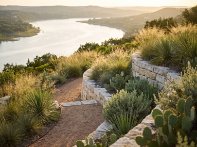
A steep slope that is left alone will move. Hillside slope stabilization and tiered terracing design breaks one long, steep face into a sequence of shorter, flatter steps. Each terrace is held by a retaining wall, usually built from limestone, and each level becomes a place where water slows, soaks in, and drops its load of soil before moving on.
Terraces do more than hold soil. They create usable ground. A planting bed, a seating area, a path, or a garden can sit on each level, turning a slope that was an obstacle into a series of rooms. Retaining walls above a certain height generally need engineering, and every wall needs proper drainage behind it so that water pressure does not build up. The base of each wall rests on a firm foundation, and the backfill is free-draining stone.
Planting as Structure
On a steep Lago Vista, TX lot, the first rains after construction are the real test. Bare soil between young plants is the most vulnerable surface on the property, so temporary cover such as erosion blankets, stone, or a layer of mulch protects the slope while roots develop. Plants are set in staggered groups rather than straight lines, since rows can channel water downhill, and the staggered pattern breaks up flow and spreads it across the slope.
Hardscape is not the only way to hold a hill. Deep-rooted plants bind soil, slow runoff, and reduce erosion over time. Native grasses with fibrous roots, shrubs with spreading root systems, and groundcovers that knit the surface together all add to the stability of a slope. In many cases, the best results come from combining structure and planting, with walls and rock handling the steepest sections and vegetation stabilizing the rest.
Managing Water on a Bluff
Limestone Bluff Stormwater Runoff and Erosion Control Layout
On a property with exposed rock, runoff behaves differently than it does on soil. A limestone bluff stormwater runoff and erosion control layout traces the path water takes from the roof, the driveway, and the upper yard to the bottom of the lot and then plans for each stage. Roof water is captured and carried in pipe to a safe discharge point. Surface flow is slowed by swales and level spreaders. Rock check dams and dry creek channels hold gradient steady and keep water from gaining speed.
At the bottom, the discharge point is designed to spread water out and reduce its energy before it leaves the property, usually with a rock apron or a vegetated buffer. Bare ground is covered with mulch, stone, or plantings so rain does not strike exposed soil directly. The objective is a landscape that treats a storm as a normal event instead of an emergency.
Highland Lakes Watershed Environmental Landscape Compliance
Lago Vista sits within the Highland Lakes region, and the lake is a shared resource. Highland Lakes watershed environmental landscape compliance means that grading, drainage, and planting near the shoreline and on steep slopes can be subject to rules that protect water quality. Requirements vary depending on the location of the property, the extent of disturbance, and the distance to the water, and they can come from the city, the county, and the agencies that manage the lake.
A designer who plans for compliance from the start avoids redesign later. Erosion controls during construction, buffers along drainage paths, limits on fertilizer and chemical use, and attention to impervious surfaces all fit within the same plan. Confirming requirements early, before the layout is final, keeps the project on schedule and protects the lake the property overlooks.
Protecting the View
Lake Travis Panoramic View Corridor Preservation Planning
The view is the reason many owners chose the lot, and good design guards it. Lake Travis panoramic view corridor preservation planning identifies the sightlines from the main living areas, the deck, and the best spots in the yard, and then keeps them clear. Tall trees are placed to the sides of the corridor or in areas where they frame the view instead of blocking it. Plants within the corridor are selected for a mature height that stays below the sightline.
Layering helps. Low plantings in the foreground lead the eye toward the lake, mid-height shrubs soften the transitions, and tall canopy trees sit at the margins to provide shade and framing. A view corridor does not have to be bare. It can be filled with texture and color as long as the heights are controlled. Planning for mature size is essential, because a tree that looks appropriate at planting may be a view-blocker in fifteen years.
Living With Fire and Deer
Firewise Defensible Space Landscape Architecture
Wildfire is a real consideration in the Hill Country, especially on hillsides where fire travels uphill quickly. Firewise defensible space landscape architecture arranges the plants and materials around a home to reduce the chance that embers or flames reach the structure. The idea is to create zones. Closest to the house, the first few feet are kept clear of flammable material and surfaced with stone, gravel, or pavers. The next zone uses low, well-spaced, moisture-rich plants. Farther out, trees are thinned and separated so fire cannot easily climb from one to another.
Firewise principles fit well with Hill Country design. Gravel paths, stone terraces, and well-spaced native plants are all fire-wise by nature. Mulch near the house can be replaced with stone, dead material is cleared regularly, and large shrubs are kept away from walls and eaves. The result is a landscape that is beautiful and also gives the property a better chance in dry, windy conditions.
Deer-Resistant Hill Country Native Plant Palette Selection
Deer are part of life in Lago Vista, and they treat an unprotected garden as a buffet. Deer-resistant Hill Country native plant palette selection chooses species they tend to avoid, such as plants with strong aromas, fuzzy or leathery leaves, and bitter or spiny textures. Texas sage, rosemary, autumn sage, yucca, agave, sotol, and many native grasses fall into this group.
No plant is truly deer-proof, especially during drought when food is scarce, so the strategy is to rely on a palette that is broadly resistant and to protect the most vulnerable plants while they establish. Placing tastier plants close to the house, within courtyards, or behind low barriers can help. Natives also have the advantage of being adapted to local rainfall, soil, and temperature, which means they need less supplemental water and handle thin limestone soil better than imported choices.
Designing for Dry Years and Living Systems
Drought-Hardy Architectural Xeriscape and Rockscape Design
The thin soil and hot summers of the hillside reward plants and materials that thrive on little. Drought-hardy architectural xeriscape and rockscape design pairs structured plantings with stone in a way that looks intentional and not sparse. Boulders anchor the corners of beds, gravel fills the spaces between plants, and sculptural plants such as agave, yucca, and sotol provide year-round form.
Rockscape suits the hillside because rock is what the site is made of. Stone feels natural, resists erosion, and requires no water. It also contributes to the Firewise strategy by replacing combustible mulch. Architectural plantings, repeated in groups for rhythm and contrast, give the composition the polish of a designed landscape while keeping the maintenance load light.
Native Ornamental Grass and Pollinator Habitat Integration
Grasses are the workhorses of a hillside. Native ornamental grass and pollinator habitat integration combines the soil-holding power of native grasses with the ecological value of flowering plants. Little bluestem, muhly, sideoats grama, and Indiangrass hold slopes with dense root systems, sway in the wind, and turn warm shades of copper and gold in autumn. Between them, native flowering perennials feed bees, butterflies, and other pollinators from spring through fall.
The combination also serves the lake. Deep-rooted grasses and perennials absorb runoff and filter it before it reaches the shoreline, and a planting that requires no fertilizer or chemical inputs protects water quality. The look is soft and natural, which suits the Hill Country setting and complements the harder lines of stone terraces.
Making the Hillside Usable
Multi-Functional Outdoor Living Zone and Circulation Mapping
A steep property can feel unusable unless the design gives people places to go and ways to get there. Multi-functional outdoor living zone and circulation mapping lays out the areas for sitting, dining, cooking, gardening, and gathering, then connects them with paths and steps that make sense for the terrain. Paths follow the contour where they can, switch back where the slope is steep, and include landings and handrails where safety calls for them.
Each zone is designed for more than one use. A terrace that serves as a dining area in the evening can double as a garden room in the morning. A landing between levels can hold a bench and a view. Seating areas placed on terraces take advantage of the flattest ground, while steps and landings are sized for comfortable use by people of all ages and abilities. Mapping circulation early ensures that people can move through the yard comfortably and that paths do not funnel water downhill. Good circulation turns a hillside from a place to look at into a place to live.
Bringing the Plan to Life
Sequence of Work on a Steep Site
Work on a slope follows a careful order. Erosion controls go in first, to protect the site during construction. Drainage and grading come next, followed by retaining walls and terraces. Paths, steps, and hardscape follow, then the soil preparation, planting, and mulch or stone cover. Lighting and irrigation are installed alongside the structure. The final stage is tuning, which includes checking drainage after the first heavy rain and adjusting as the plants establish.
Ongoing Care
After installation, the hillside needs regular attention in the first year or two. New plants need supplemental water until they are established, and any erosion that appears after a storm should be addressed promptly. A lawn care service that understands the design can maintain turf edges, clear debris from drainage paths, and manage seasonal cleanup without disturbing the slope. Heroes Lawn Care of Cedar Park provides guidance on how each part of the landscape should be cared for so the design continues to perform as it matures.
Questions to Ask Before Designing a Hillside
A few questions separate a thoughtful plan from a generic one. How will water move across the site, and where will it leave? What will hold the soil on the steepest sections? Which sightlines need protection, and how tall will the plants grow? What rules apply near the lake? How will the design reduce fire risk? Which plants will deer leave alone? How will people move through the yard? Clear answers show a designer who has read the site instead of applying a template.
A Hillside That Stays Put
A steep lot above Lake Travis can become one of the most striking landscapes in the Hill Country, with terraces stepping down toward the water, native grasses moving in the wind, and the lake framed from every seat. It stays that way when the design respects the slope, the rock, the water, and the sky, and when planning comes before planting.
For property owners across Lago Vista, TX who want that kind of result, Heroes Lawn Care of Cedar Park provides landscape design that begins with a walk down the slope, a study of how water moves, and a clear picture of the view worth keeping. The best next step is to see the lot with a plan in hand and to let the land set the order of work.